CA MARINE PROTECTED AREAS, YEAR 2
NORTHERN & CENTRAL CA
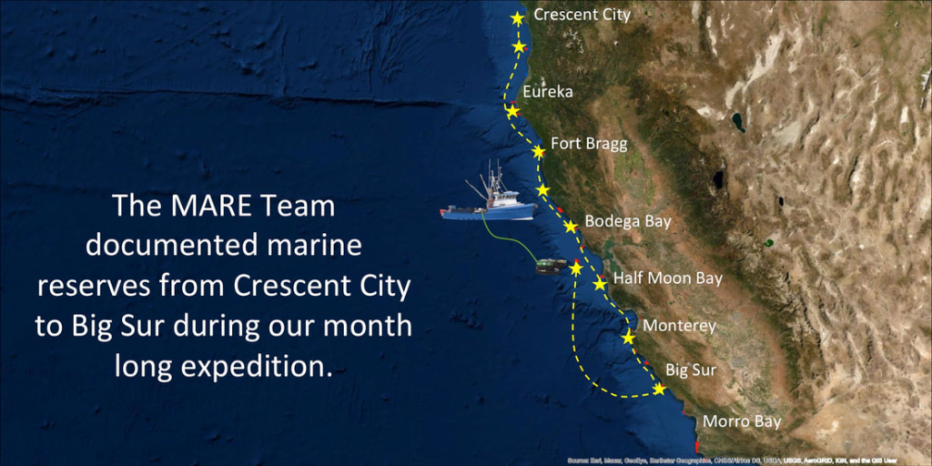
MARE continued the Long Term Monitoring of California’s network of Marine Protected Areas (MPA) during a month-long expedition, from September to October 2020. We visited 11 pairs of sites (MPAs and fished reference sites) that were previously surveyed by MARE and California Department of Fish and Wildlife (CDFW) from Crescent City to Point Sur. Results from this expedition will be shared with academic partners who will perform analysis to help inform the State in its review of the performance of MPAs to-date.
EXPEDITION HIGHLIGHTS
EXPEDITION PHOTOS
BIG CREEK STATE MARINE RESERVE
This stretch of California’s rugged coast between Carmel and San Simeon is bordered on the east by mountains and on the west by the Pacific Ocean, and traversed by the narrow winding two- lane Route 1.
FARALLON ISLANDS
Native Americans called the Farallon Islands the “Islands of the Dead” and mariners referred to them as “the devil’s teeth” for their ragged profile and treacherous shores. But the name that stuck was the Spanish farallón, meaning a rocky promontory jutting from the ocean
The islands are managed by the U.S. Fish and Wildlife Service and are located nearly 30 miles off the coast of San Francisco. The Farallones host globally significant wildlife populations, including hundreds of thousands of seabirds and thousands of seals and sea lions.
MONTARA STATE MARINE RESERVE
PILLAR POINT STATE MARINE CONSERVATION AREA
Located about 20 miles south of San Francisco, Montara State Marine Reserve is surrounded by Monterey Bay National Marine Sanctuary. The north end of Montara SMR is guarded by Point Montara Lighthouse, the only lighthouse in the United States that has guided sailors through rough seas on both coasts. Built in Boston in the late 1800s, the lighthouse spent it’s first 50 years overlooking Cape Cod. Dismantled and thought to be recycled for scrap metal, the structure mysteriously reappeared on Point Montara in 1928, yet no one knows exactly how, or why, it made its cross-country journey
Pillar Point SMCA is located next to one of the most feared surf breaks on the planet the wave at ‘Mavericks’, created by the unique depth and shape of the underwater terrain that concentrates energy onto a shallow rocky reef. This produces waves greater than 50 feet tall and has a reputation for being one of the deadliest waves on Earth; a place where daredevils are willing to risk their bodies for the drop of their lives.
BODEGA HEAD STATE MARINE RESERVE
Bodega Bay was originally founded by the Russians in 1809 as a shelter for their otter hunters, it later led to the establishment of Fort Ross, the most southern Russian settlement on the west coast. It was later renamed for the Spanish explorer Juan Francisco de la Bodega y Quadra. This bay is located just East of the two offshore jewels of the of the National Marine Sanctuary system: the Greater Gulf of the Farallones and Cordell Banks.
Offshore of Bodega Head lies one of the most expansive rocky reefs in northern California. The reef encompasses an area of about 10 square miles and extends to a depth of 260 feet. The large extent and depth range of this reef creates important habitats for a wide range of species.
POINT ARENA STATE MARINE RESERVE
Located 150 miles north of San Francisco, Point Arena has some of the most persistent upwelling along the California coast and make it a remarkable biodiversity hotspot. This area lies between Russian river to the South, and the Navarro river to the North. A prominent marine terrace jutting west into the Pacific provides a fine shelter for vessels from the prevailing Northwest winds.
TEN MILE STATE MARINE RESERVE
SEA LION GULCH STATE MARINE RESERVE
READING ROCK STATE MARINE RESERVE
POINT ST. GEORGE REEF OFFSHORE SMCA


